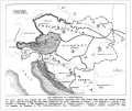
Ficheiro:AustriaHungaryWWI.gif

Dimensões desta antevisão: 681 × 599 píxeis. Outras resoluções: 273 × 240 píxeis | 545 × 480 píxeis | 776 × 683 píxeis.
Imagem numa resolução maior (776 × 683 píxeis, tamanho: 98 kB, tipo MIME: image/gif)
Histórico do ficheiro
Clique uma data e hora para ver o ficheiro tal como ele se encontrava nessa altura.
| Data e hora | Miniatura | Dimensões | Utilizador | Comentário | |
|---|---|---|---|---|---|
| atual | 05h39min de 26 de janeiro de 2022 |  | 776 × 683 (98 kB) | GPinkerton | Reverted to version as of 22:53, 20 January 2009 (UTC) COM:CROP, manipulation of historical images |
| 11h11min de 27 de dezembro de 2021 |  | 762 × 642 (97 kB) | Claude Zygiel | Sub-Carpathian Ruthenia never was Polish, this is not a "historical map" but an error of a newspaper: correcting it is not "manipulation". | |
| 04h31min de 27 de setembro de 2021 |  | 776 × 683 (98 kB) | GPinkerton | Reverted to version as of 22:53, 20 January 2009 (UTC) COM:CROP, manipulation of historical images | |
| 09h27min de 23 de julho de 2020 |  | 762 × 642 (97 kB) | Claude Zygiel | Better (see [https://commons.wikimedia.org/wiki/File:Dissolution_of_Austria-Hungary.png]) | |
| 22h53min de 20 de janeiro de 2009 |  | 776 × 683 (98 kB) | Bizso | {{Information |Description={{en|New hand-drawn borders of Austria-Hungary in the Treaty of Trianon and Saint Germain.}} |Source=Transferred from [http://en.wiki.x.io en.wikipedia]; transfer was stated to be made by User:Bizso.<br/> (Original text |
Utilização local do ficheiro
A seguinte página usa este ficheiro:
Utilização global do ficheiro
As seguintes wikis usam este ficheiro:
- azb.wiki.x.io
- bg.wiki.x.io
- ca.wiki.x.io
- cy.wiki.x.io
- el.wiki.x.io
- en.wiki.x.io
- ga.wiki.x.io
- gl.wiki.x.io
- he.wiki.x.io
- hr.wiki.x.io
- hy.wiki.x.io
- id.wiki.x.io
- it.wiki.x.io
- ko.wiki.x.io
- lv.wiki.x.io
- pnb.wiki.x.io
- ru.wiki.x.io
- sh.wiki.x.io
- simple.wiki.x.io
- sk.wiki.x.io
- th.wiki.x.io
- ur.wiki.x.io
- vi.wiki.x.io
- zh.wiki.x.io


