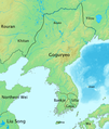
Ficheiro:History of Korea-476.PNG

Dimensões desta antevisão: 507 × 599 píxeis. Outras resoluções: 203 × 240 píxeis | 406 × 480 píxeis | 970 × 1 146 píxeis.
Imagem numa resolução maior (970 × 1 146 píxeis, tamanho: 866 kB, tipo MIME: image/png)
Histórico do ficheiro
Clique uma data e hora para ver o ficheiro tal como ele se encontrava nessa altura.
| Data e hora | Miniatura | Dimensões | Utilizador | Comentário | |
|---|---|---|---|---|---|
| atual | 08h51min de 4 de outubro de 2008 |  | 970 × 1 146 (866 kB) | Historiographer~commonswiki | {{Information |Description= |Source= |Date= |Author= |Permission= |other_versions= }} |
| 05h37min de 3 de julho de 2008 |  | 970 × 1 146 (571 kB) | Historiographer~commonswiki | {{Information |Description= |Source= |Date= |Author= |Permission= |other_versions= }} | |
| 14h48min de 14 de junho de 2008 |  | 970 × 1 146 (873 kB) | Historiographer~commonswiki | {{Information |Description= |Source= |Date= |Author= |Permission= |other_versions= }} | |
| 14h46min de 14 de junho de 2008 |  | 970 × 1 146 (568 kB) | Historiographer~commonswiki | {{Information |Description= |Source= |Date= |Author= |Permission= |other_versions= }} | |
| 13h47min de 12 de junho de 2008 |  | 970 × 1 146 (874 kB) | Historiographer~commonswiki | {{Information |Description={{en|1=The map of history of Korea in 476, The greatest territory expansion of Goguryeo. }} {{ko|1=한국사 지도 - 476년, 고구려 전성기때의 지도.}} |Source=Self-made |Author=Myself |Date=2008-06-10 |Permission= |ot |
Utilização local do ficheiro
As seguintes 3 páginas usam este ficheiro:
Utilização global do ficheiro
As seguintes wikis usam este ficheiro:
- af.wiki.x.io
- ang.wiki.x.io
- ast.wiki.x.io
- azb.wiki.x.io
- az.wiki.x.io
- ba.wiki.x.io
- be-tarask.wiki.x.io
- be.wiki.x.io
- br.wiki.x.io
- bs.wiki.x.io
- ca.wiki.x.io
- cdo.wiki.x.io
- ckb.wiki.x.io
- cs.wiki.x.io
- cy.wiki.x.io
- da.wiki.x.io
- da.wikibooks.org
- de.wiki.x.io
- en.wiki.x.io
Ver mais utilizações globais deste ficheiro.