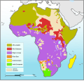
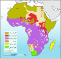
Ficheiro:Languages of Africa map.svg

Dimensões desta antevisão em PNG do ficheiro SVG: 629 × 599 píxeis Outras resoluções: 252 × 240 píxeis | 504 × 480 píxeis | 806 × 768 píxeis | 1 075 × 1 024 píxeis | 2 150 × 2 048 píxeis | 1 534 × 1 461 píxeis.
Imagem numa resolução maior (ficheiro SVG, de 1 534 × 1 461 píxeis, tamanho: 750 kB)
Histórico do ficheiro
Clique uma data e hora para ver o ficheiro tal como ele se encontrava nessa altura.
| Data e hora | Miniatura | Dimensões | Utilizador | Comentário | |
|---|---|---|---|---|---|
| atual | 03h17min de 16 de dezembro de 2010 |  | 1 534 × 1 461 (750 kB) | Brianski | Color Bioko Island (Equatorial Guinea), as well as São Tome and Principe, acccording to ethnologue. Not sure what color to use for Annobón, so I left it blank. |
| 03h05min de 16 de dezembro de 2010 |  | 1 534 × 1 461 (750 kB) | Brianski | It was really hard to tell water from Khoi-San and Nilo-Saharan, particularly confusing in the Great Lakes area, so I chose a new color scheme. | |
| 03h04min de 16 de dezembro de 2010 |  | 1 534 × 1 461 (750 kB) | Brianski | It was really hard to tell great lakes from Khoi-San and Nilo-Saharan, particularly confusing in the Great Lakes area, so I chose a new color scheme. | |
| 16h31min de 20 de agosto de 2010 |  | 1 534 × 1 461 (750 kB) | P. S. Burton | coloured non-African areas 10% grey. They were the same colour as the "sparsely populated areas". | |
| 11h09min de 11 de janeiro de 2010 |  | 1 534 × 1 461 (750 kB) | Brianski | changed to mark all of madagascar in yellow, as madagascar's malagasy-speaking population is not concentrated in the north and west as this map implies - see: http://maps.nationmaster.com/country/ma/1 http://www.ethnologue.com/show_map.asp?name=MG&seq=10 | |
| 08h33min de 8 de agosto de 2009 |  | 1 534 × 1 461 (753 kB) | Seb az86556 | adjustment (Namibia) | |
| 07h32min de 8 de agosto de 2009 |  | 1 534 × 1 461 (765 kB) | Seb az86556 | {{Information |Description={{en|1=Languages of Africa map}} |Source=Own work by uploader |Author=Seb az86556 |Date=2009-08-08 |Permission= |other_versions= }} Category:Linguistic maps of Africa Category:SVG linguistic maps [[ |
Utilização local do ficheiro
As seguintes 2 páginas usam este ficheiro:
Utilização global do ficheiro
As seguintes wikis usam este ficheiro:
- ar.wiki.x.io
- ca.wiki.x.io
- en.wiki.x.io
- fr.wiki.x.io
- fr.wiktionary.org
- lfn.wiki.x.io
- lv.wiki.x.io
- nn.wiki.x.io
- pnb.wiki.x.io
- ru.wiki.x.io
- uk.wiki.x.io


