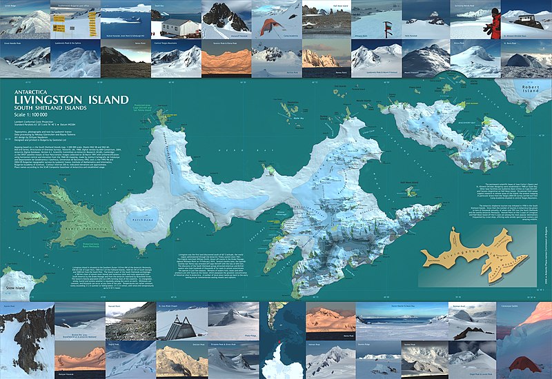
Ficheiro:Livingston-Greenwich-map.jpg

Dimensões desta antevisão: 800 × 550 píxeis. Outras resoluções: 320 × 220 píxeis | 640 × 440 píxeis | 1 024 × 705 píxeis | 1 280 × 881 píxeis | 2 560 × 1 761 píxeis | 7 828 × 5 386 píxeis.
Imagem numa resolução maior (7 828 × 5 386 píxeis, tamanho: 5,07 MB, tipo MIME: image/jpeg)
Histórico do ficheiro
Clique uma data e hora para ver o ficheiro tal como ele se encontrava nessa altura.
| Data e hora | Miniatura | Dimensões | Utilizador | Comentário | |
|---|---|---|---|---|---|
| atual | 16h22min de 27 de maio de 2007 |  | 7 828 × 5 386 (5,07 MB) | Apcbg | Reverted to earlier revision |
| 18h38min de 23 de maio de 2007 |  | 7 828 × 5 386 (19,01 MB) | Apcbg | == Summary == L.L. Ivanov et al, Antarctica: Livingston Island, South Shetland Islands (from English Strait to Morton Strait, with illustrations and ice-cover distribution), 1:100000 scale topographic map, Antarctic Place-names Commission of Bulgaria, Sof | |
| 11h47min de 15 de junho de 2006 |  | 7 828 × 5 386 (5,07 MB) | Apcbg | L.L. Ivanov et al, Antarctica: Livingston Island, South Shetland Islands (from English Strait to Morton Strait, with illustrations and ice-cover distribution), 1:100000 scale topographic map, Antarctic Place-names Commission of Bulgaria, Sofia, 2005 Rel | |
| 06h27min de 25 de maio de 2006 |  | 7 828 × 5 386 (4,79 MB) | Apcbg | L.L. Ivanov et al, Antarctica: Livingston Island, South Shetland Islands (from English Strait to Morton Strait, with illustrations and ice-cover distribution), 1:100000 scale topographic map, Antarctic Place-names Commission of Bulgaria, Sofia, 2005 Rel |
Utilização local do ficheiro
As seguintes 3 páginas usam este ficheiro:
Utilização global do ficheiro
As seguintes wikis usam este ficheiro:
- af.wiki.x.io
- ar.wiki.x.io
- bg.wiki.x.io
- ca.wiki.x.io
- cs.wiki.x.io
- cv.wiki.x.io
- de.wiki.x.io
- el.wiki.x.io
- en.wiki.x.io
- Cartography
- Wikipedia:Picture peer review/Map of Livingston Island and Greenwich Island
- Wikipedia:Featured picture candidates/April-2007
- Wikipedia:Featured picture candidates/Map of Livingston Island and Greenwich Island
- User:Apcbg/Livingston-Greenwich-map
- Barclay Bay
- Portal:Maps
- Map layout
- Cartographic design
- Wikipedia:Wikipedia for Schools/Welcome/Geography
- Portal:Geodesy
- eo.wiki.x.io
- es.wiki.x.io
- fa.wiki.x.io
- fr.wiki.x.io
- he.wiki.x.io
- hr.wiki.x.io
- hu.wiki.x.io
- it.wiki.x.io
- ja.wiki.x.io
- ka.wiki.x.io
- kk.wiki.x.io
- la.wiki.x.io
- mk.wiki.x.io
- ms.wiki.x.io
- my.wiki.x.io
- nl.wiki.x.io
- nn.wiki.x.io
- no.wiki.x.io
Ver mais utilizações globais deste ficheiro.
