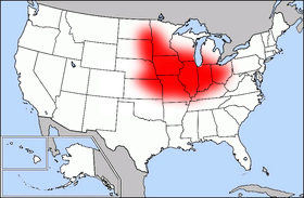
Ficheiro:Map of USA highlighting Corn Belt.png
Map_of_USA_highlighting_Corn_Belt.png (280 × 183 píxeis, tamanho: 41 kB, tipo MIME: image/png)
Histórico do ficheiro
Clique uma data e hora para ver o ficheiro tal como ele se encontrava nessa altura.
| Data e hora | Miniatura | Dimensões | Utilizador | Comentário | |
|---|---|---|---|---|---|
| atual | 10h55min de 24 de março de 2007 |  | 280 × 183 (41 kB) | PDD | {{Information |Description=Public domain map courtesy of [http://www.lib.utexas.edu/ The General Libraries, The University of Texas at Austin], modified (by • Benc • 00:30, 13 Aug 2004 (UTC)) to highlight regio |
Utilização local do ficheiro
As seguintes 2 páginas usam este ficheiro:
Utilização global do ficheiro
As seguintes wikis usam este ficheiro:
- ar.wiki.x.io
- ast.wiki.x.io
- ca.wiki.x.io
- cs.wiki.x.io
- de.wiki.x.io
- eo.wiki.x.io
- es.wiki.x.io
- he.wiki.x.io
- pl.wiki.x.io
- pt.wikibooks.org
- www.wikidata.org
