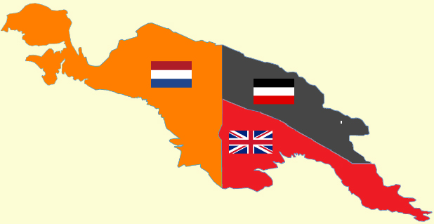
Ficheiro:New Guinea (1884-1919).png
New_Guinea_(1884-1919).png (618 × 319 píxeis, tamanho: 60 kB, tipo MIME: image/png)
Histórico do ficheiro
Clique uma data e hora para ver o ficheiro tal como ele se encontrava nessa altura.
| Data e hora | Miniatura | Dimensões | Utilizador | Comentário | |
|---|---|---|---|---|---|
| atual | 23h38min de 22 de setembro de 2009 |  | 618 × 319 (60 kB) | Jayen466 | Content changes as described in previous edit, but this time in png format. The previous edit did not take, probably because I tried to upload in jpg format rather than png. |
| 23h32min de 22 de setembro de 2009 |  | 618 × 319 (87 kB) | Jayen466 | Adjusted the border between Kaiser-Wilhelmsland and British Papua in Photoshop, based on the more reliable map at http://up.wiki.x.io/wikipedia/commons/4/4e/Map-Kaiser-Wilhelms-Land-und-Bismarck-Archipel.png – according to several contemporary R | |
| 04h47min de 10 de julho de 2008 |  | 618 × 319 (25 kB) | Cartol | {{Information |Description=Political map of the island of New Guinea from 1884-1919. |Source=Self-created map. Outline of New Guinea based on Image:New guinea named.PNG. Flags from Image:Flag of the United Kingdom.svg, [[:Image:Flag of the Neth |
Utilização local do ficheiro
As seguintes 3 páginas usam este ficheiro:
Utilização global do ficheiro
As seguintes wikis usam este ficheiro:
- af.wiki.x.io
- als.wiki.x.io
- ar.wiki.x.io
- ast.wiki.x.io
- be-tarask.wiki.x.io
- be.wiki.x.io
- bn.wiki.x.io
- bs.wiki.x.io
- ca.wiki.x.io
- cbk-zam.wiki.x.io
- cs.wiki.x.io
- de.wiki.x.io
- en.wiki.x.io
- History of Oceania
- Oceania
- Papua New Guinea
- Kaiser-Wilhelmsland
- Germany–United Kingdom relations
- New Guinea
- Postage stamps and postal history of Papua New Guinea
- Hermann Detzner
- Talk:Hermann Detzner
- User:Cruickshanks/Sandbox
- User:Cruickshanks/sandbox3
- User:Cruickshanks/sandbox4
- The Ballad of the Salty Sea
- Indonesia–Papua New Guinea border
- Portal:New Guinea
- es.wiki.x.io
Ver mais utilizações globais deste ficheiro.


