Ficheiro:Ocean drainage.png
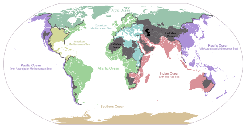
Imagem numa resolução maior (1 256 × 656 píxeis, tamanho: 75 kB, tipo MIME: image/png)

Any autoconfirmed user can overwrite this file from the same source. Please ensure that overwrites comply with the guideline.

Descrição do ficheiro

Esta imagem de mapas (ou todas as imagens neste artigo ou categoria) deveriam ser recriadas usando gráficos vectoriais, como ficheiros SVG. Isto tem várias vantagens; veja as Commons:Media for cleanup|imagens para rever para mais informações. Se já criou um ficheiro SVG desta imagem, por favor, carregue-o. Depois do novo ficheiro SVG ter sido carregado, substitua aqui esta predefinição pela predefinição {{vector version available|nome da nova imagem.svg}}.
Descrição
English: I made this map and hereby release it into the public domain. It shows the drainage basins for the major oceans and seas; grey areas are endorheic basins that do not drain to the ocean. Data is from the USGS Hydro1k project; information for Saskatchewan corrected by information from the Commission for Environmental Cooperation -- Citynoise
Description in large font size is used for oceans, in smaller font size is used for mediterranean seas. Only these mediterranean seas are listed which correspond to the definition of german Geographer Ernst Neef: A mediterranean sea is a sea between two Continents. Also found here: de:Mittelmeer --W like wiki (talk) 00:55, 12 March 2011 (UTC)
Français : Carte du monde des bassins versants. Les zones de couleur anthracite représentent les bassins endoréiques, qui ne sont reliés à aucun océan.
Čeština: Úmoří světových oceánů, popř. významných moří či zálivů. Legenda úmoří: fialová - Tichý oceán, růžová - Indický oceán, zelená - Atlantický oceán, azurová - Severní ledový oceán, béžová - Jižní oceán, modrá - Mexický záliv, světle modrá - Středozemní moře, šedá - oblast neústící ve světovém oceánu
Data 24 de janeiro de 2007 (data de carregamento original)
Origem Transferido de en.wikipedia para a wiki Commons.
Autor Citynoise em Wikipédia em inglês
Outras versões File:Major endorheic basins.png

Licenciamento

Public domain Esta obra foi dedicada ao domínio público pelo autor, Citynoise em Wikipédia em inglês, com aplicação em todo o mundo.
Nalguns países isto pode não ser legalmente possível; se assim for:
Citynoise concede a todos o direito de usar esta obra para qualquer fim, sem quaisquer condições, a menos que tais condições sejam impostas por lei.

Registo de carregamento original

A página de descrição original está aqui. Todos os nomes de utilizador a seguir referem-se a en.wikipedia.
  • 2007-05-20 17:59 Bolonium 1256×656×8 (50194 bytes) I made this map and hereby release it into the public domain. It shows the drainage basins for the major oceans and seas; grey areas are endorheic basins that do not drain to the ocean. -- [[User:Citynoise|Citynoise]] == Licensing == {{self
  • 2007-01-24 07:21 Citynoise 1256×656×8 (63359 bytes) I made this map and hereby release it into the public domain. It shows the drainage basins for the major oceans and seas; grey areas are endorheic basins that do not drain to the ocean.
  • 2007-01-24 06:09 Citynoise 1256×656×8 (57358 bytes) I made this map and hereby release it into the public domain. It shows the drainage basins for the major oceans and seas; grey areas are endorheic basins that do not drain to the ocean.
  • 2007-01-24 05:10 Citynoise 1256×656×8 (56360 bytes) I made this map and hereby release it into the public domain. It shows the drainage basins for the major oceans and seas; grey areas are endorheic basins that do not drain to the ocean.
  • 2007-01-24 04:55 Citynoise 1256×656×8 (56373 bytes) I made this map and hereby release it into the public domain. It shows the drainage basins for the major oceans and seas; grey areas are endorheic basins that do not drain to the ocean.

Legendas

Adicione uma explicação de uma linha do que este ficheiro representa
Drainage basins of the world, colored by ocean outlet. Endorheic basins not draining to an ocean are colored dark gray. Continental divides are indicated by dark lines.

Elementos retratados neste ficheiro

retrata

76 631 byte

656 pixel

1 256 pixel

d5b64057aaa6c06ef1d87165441c69fd68a28392

Histórico do ficheiro

Clique uma data e hora para ver o ficheiro tal como ele se encontrava nessa altura.

Data e horaMiniaturaDimensõesUtilizadorComentário
atual23h25min de 6 de outubro de 2015Miniatura da versão das 23h25min de 6 de outubro de 20151 256 × 656 (75 kB)AcidSnowFixed Somalia.
00h39min de 12 de março de 2011Miniatura da versão das 00h39min de 12 de março de 20111 256 × 656 (76 kB)W like wikiInsert Description. Big font size is used for oceans, smaller font size is used for mediterranean seas.
11h13min de 30 de junho de 2009Miniatura da versão das 11h13min de 30 de junho de 20091 256 × 656 (40 kB)U7vGuntransparentize background,improve some details.
20h45min de 26 de julho de 2008Miniatura da versão das 20h45min de 26 de julho de 20081 256 × 656 (62 kB)Citynoise{{Information |Description=added endorheic basins in Saskatchewan. |Source=my own work |Date=July 2008 |Author=Citynoise |Permission=all rights released |other_versions= }}
19h46min de 27 de novembro de 2007Miniatura da versão das 19h46min de 27 de novembro de 20071 256 × 656 (49 kB)File Upload Bot (Magnus Manske) {{BotMoveToCommons|en.wikipedia}} {{Information |Description={{en|I made this map and hereby release it into the public domain. It shows the drainage basins for the major oceans and seas; grey areas are en:endorheic basins that do not drain to the

As seguintes 2 páginas usam este ficheiro:

Utilização global do ficheiro

Metadados