Ficheiro:PIA18822-LunarGrailMission-OceanusProcellarum-Rifts-Overall-20141001.jpg
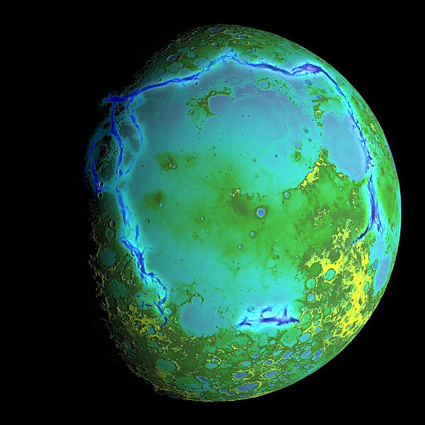
Imagem numa resolução maior (1 500 × 1 500 píxeis, tamanho: 199 kB, tipo MIME: image/jpeg)

Descrição do ficheiro

Descrição
English: PIA18822: Gravity Gradients Frame Oceanus Procellarum

October 1, 2014

http://photojournal.jpl.nasa.gov/catalog/PIA18822

Topography of Earth's moon generated from data collected by the Lunar Orbiter Laser Altimeter, aboard NASA's Lunar Reconnaissance Orbiter, with the gravity anomalies bordering the Procellarum region superimposed in blue. The border structures are shown using gravity gradients calculated with data from NASA's Gravity Recovery and Interior Laboratory (GRAIL) mission. These gravity anomalies are interpreted as ancient lava-flooded rift zones buried beneath the volcanic plains (or maria) on the nearside of the Moon.

Launched as GRAIL A and GRAIL B in September 2011, the probes, renamed Ebb and Flow, operated in a nearly circular orbit near the poles of the moon at an altitude of about 34 miles (55 kilometers) until their mission ended in December 2012. The distance between the twin probes changed slightly as they flew over areas of greater and lesser gravity caused by visible features, such as mountains and craters, and by masses hidden beneath the lunar surface.

The twin spacecraft flew in a nearly circular orbit until the end of the mission on Dec. 17, 2012, when the probes intentionally were sent into the moon's surface. NASA later named the impact site in honor of late astronaut Sally K. Ride, who was America's first woman in space and a member of the GRAIL mission team.

GRAIL's prime and extended science missions generated the highest-resolution gravity field map of any celestial body. The map will provide a better understanding of how Earth and other rocky planets in the solar system formed and evolved.

The GRAIL mission was managed by NASA's Jet Propulsion Laboratory (JPL) in Pasadena, California, for NASA's Science Mission Directorate in Washington. The mission was part of the Discovery Program managed at NASA's Marshall Space Flight Center in Huntsville, Alabama. GRAIL was built by Lockheed Martin Space Systems in Denver.

For more information about GRAIL, please visit http://grail.nasa.gov.
Data
Origem http://photojournal.jpl.nasa.gov/jpeg/PIA18822.jpg
Autor NASA/Colorado School of Mines/MIT/GSFC/Scientific Visualization Studio

Licenciamento

Public domain Este ficheiro está no domínio público nos Estados Unidos porque foi criado exclusivamente pela NASA. As orientações sobre o direito de autor da NASA são que «as obras da NASA não têm os direitos de autor protegidos salvo indicação em contrário». Veja Template:PD-USGov, as orientações sobre o direito de autor da NASA ou as normas de uso de imagens do Laboratório de Propulsão a Jato (Jet Propulsion Lab, JPL).
Avisos:

Legendas

Adicione uma explicação de uma linha do que este ficheiro representa

Elementos retratados neste ficheiro

retrata

203 499 byte

1 500 pixel

1 500 pixel

image/jpeg

2ef06a847fd8eaeee8df4d458563c03a75f8fe8a

Histórico do ficheiro

Clique uma data e hora para ver o ficheiro tal como ele se encontrava nessa altura.

Data e horaMiniaturaDimensõesUtilizadorComentário
atual02h30min de 5 de outubro de 2014Miniatura da versão das 02h30min de 5 de outubro de 20141 500 × 1 500 (199 kB)DrbogdanUser created page with UploadWizard

A seguinte página usa este ficheiro:

Utilização global do ficheiro

As seguintes wikis usam este ficheiro:

Ver mais utilizações globais deste ficheiro.