Ficheiro:PrunellaCollariusIUCN.png

Imagem numa resolução maior (3 507 × 2 480 píxeis, tamanho: 1,35 MB, tipo MIME: image/png)

File:PrunellaCollarisIUCN.svg é uma versão vetorial deste ficheiro. Ela deve ser usada em vez desta imagem em formato raster, se não for de qualidade inferior.

File:PrunellaCollariusIUCN.png → File:PrunellaCollarisIUCN.svg

Para mais informações, consulte Ajuda:SVG.

Em outras línguas
Alemannisch  العربية  беларуская (тарашкевіца)  български  বাংলা  català  нохчийн  čeština  dansk  Deutsch  Ελληνικά  English  British English  Esperanto  español  eesti  euskara  فارسی  suomi  français  Frysk  galego  Alemannisch  עברית  hrvatski  magyar  հայերեն  Bahasa Indonesia  Ido  italiano  日本語  ქართული  한국어  lietuvių  македонски  മലയാളം  Bahasa Melayu  norsk bokmål  Plattdüütsch  Nederlands  norsk nynorsk  norsk  occitan  polski  prūsiskan  português  português do Brasil  română  русский  sicilianu  Scots  slovenčina  slovenščina  српски / srpski  svenska  தமிழ்  ไทย  Türkçe  татарча / tatarça  українська  vèneto  Tiếng Việt  中文  中文(中国大陆)  中文(简体)  中文(繁體)  中文(马来西亚)  中文(新加坡)  中文(臺灣)  中文(臺灣)  +/−
Nova imagem SVG

Descrição do ficheiro

Descrição
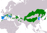
Slovenčina: Mapa rozšírenia druhu vrchárka červenkavá Prunella collaris podľa IUCN verzia 2020.1 (zostavil: BirdLife International and Handbook of the Birds of the World (2016) 2006.):
legenda: Hniezdiaca, výskyt v letnom období (#00FF00), Hniezdiaca, celoročný výskyt (#008000), Nehniezdiaca (#007FFF)
English: Distribution map of alpine accentor Prunella collaris according to IUCN version 2020.1 (compiled by: BirdLife International and Handbook of the Birds of the World (2016) 2006.); key:
Legend: Extant, breeding (#00FF00), Extant, resident (#008000), Extant, non-breeding (#007FFF)
Data
Origem Made with Natural Earth. Free vector and raster map data @ naturalearthdata.com. Range map from BirdLife International. 2016. Prunella collaris. The IUCN Red List of Threatened Species 2016: e.T22718617A88039291. https://dx.doi.org/10.2305/IUCN.UK.2016-3.RLTS.T22718617A88039291.en. Downloaded on 26 May 2020 as visual indicator of distribution.
Autor SanoAK: Alexander Kürthy

Licenciamento

O uso de dados espaciais do site da lista vermelha do UICN para produzir mapas de distribuição de espécies está sujeito à Licença Creative Commons Atribuição-Compartilhamento pela mesma licença 3.0. Em suma: você é livre de distribuir e modificar o ficheiro desde que faça atribuição aos autores e à Lista Vermelha do UICN.

العربيَّة | English | español | français | македонски | മലയാളം | português | +/−

w:pt:Creative Commons
atribuição partilha nos termos da mesma licença
A utilização deste ficheiro é regulada nos termos da licença Creative Commons - Atribuição-CompartilhaIgual 3.0 Não Adaptada.
Atribuição: IUCN Red List of Threatened Species, species assessors and the authors of the spatial data.
Pode:
  • partilhar – copiar, distribuir e transmitir a obra
  • recombinar – criar obras derivadas
De acordo com as seguintes condições:
  • atribuição – Tem de fazer a devida atribuição da autoria, fornecer uma hiperligação para a licença e indicar se foram feitas alterações. Pode fazê-lo de qualquer forma razoável, mas não de forma a sugerir que o licenciador o apoia ou subscreve o seu uso da obra.
  • partilha nos termos da mesma licença – Se remisturar, transformar ou ampliar o conteúdo, tem de distribuir as suas contribuições com a mesma licença ou uma licença compatível com a original.

Legendas

Adicione uma explicação de uma linha do que este ficheiro representa
map of alpine accentor (Prunella collaris)

Elementos retratados neste ficheiro

retrata

eb13565aa28ddde8fff3b9ef3a647f9516a6c210

1 412 265 byte

2 480 pixel

3 507 pixel

Histórico do ficheiro

Clique uma data e hora para ver o ficheiro tal como ele se encontrava nessa altura.

Data e horaMiniaturaDimensõesUtilizadorComentário
atual03h59min de 26 de maio de 2020Miniatura da versão das 03h59min de 26 de maio de 20203 507 × 2 480 (1,35 MB)SanoAKUploaded a work by SanoAK: Alexander Kürthy from Made with Natural Earth. Free vector and raster map data @ naturalearthdata.com. Range map from BirdLife International. 2016. Prunella collaris. The IUCN Red List of Threatened Species 2016: e.T22718617A88039291. https://dx.doi.org/10.2305/IUCN.UK.2016-3.RLTS.T22718617A88039291.en. Downloaded on 26 May 2020 as visual indicator of distribution. with UploadWizard

A seguinte página usa este ficheiro:

Utilização global do ficheiro

As seguintes wikis usam este ficheiro: