Ficheiro:Venezuela - Apure - Achaguas.svg

Imagem numa resolução maior (ficheiro SVG, de 512 × 209 píxeis, tamanho: 1,69 MB)
|
|
Esta imagem provém do Wikimedia Commons, um acervo de conteúdo livre da Wikimedia Foundation que pode ser utilizado por outros projetos.
|
Índice
Descrição do ficheiro
![]() This SVG map is part of a locator map series applying the widespread location map scheme. Please see root category to browse for more.
This SVG map is part of a locator map series applying the widespread location map scheme. Please see root category to browse for more.
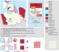
Locator maps design recommendations ▼ | |
|---|---|
Principles
Design Guidelines are based on ▸location map design of the German map shop (in German). It's preferable to derive new locator maps from existing location maps. Please keep both size and ratio in this case. Thus the new locator maps may still be applied as location map (▸Guide). Marker color is supposed to be darkred. Waterbodies may be transparent, to show other objects better. Please be aware that this guide is only a recommendation. It’s not an inevitable law!
Highlight small areas
“Remote” areas and mini maps
Mini maps show where the depicted area actually is situated. Check out ▸Vorlage:Positionskarte+ (in German) and ▸Modèle:Carte en coin (in French) of how to insert a mini map in virtually every map.
Disputed areas
Greyed special objects
Backgrounds
|
Map legend
- C12836 → Marked administrative territory
- FDFBEA → Marked state/province
- F6E1B9 → Other state/provinces of Venezuela
- DFDFDF → Other countries
- 656564 → Lines/boundaries
Mini map legend
- C12836 → Marked state/province
- FDFBEA → Rest of Venezuela
- DFDFDF → Other countries
- 656564 → Lines/boundaries
- C7E7FB → Water
- 000000 → Mini map border box
Geographic limits of the map (EPSG:4326)
- N: 8.3145
- S: 5.6351
- W: 72.6550
- E: 66.0251
Licenciamento
| DescriçãoVenezuela - Apure - Achaguas.svg |
English: Locator map of Municipio Achaguas; in Apure, Venezuela |
|||||||||
| SVG desenvolvimento InfoField | O código-fonte desta imagem SVG é válido. Esta carta geográfica foi criada com o Adobe Illustrator |
|||||||||
| Data | ||||||||||
| Origem | OpenStreetMap data, extracted via QGIS software. | |||||||||
| Criador |
contribuidores do OpenStreetMap |
|||||||||
| Permissão (Reutilizar este ficheiro) |
OpenStreetMap data is available under the Open Database License (details). Standard style map tiles are licensed as ODbL Produced Works.
|
|||||||||
| Dados geotemporais | ||||||||||
| Caixa delimitadora |
|
|||||||||
| Boundaries geometry from OpenStreetMap has been simplified to optimize its indexing in Wikimedia projects. The boundaries lines shown in this image may be of lower quality than those shown in OpenStreetMap project, or in real life. |
Legendas
Elementos retratados neste ficheiro
retrata
Um valor sem um elemento no repositório Wikidata
24 outubro 2015
image/svg+xml
1 767 539 byte
52223e7f3b85fcb53bc2f3893758699252efb584
Histórico do ficheiro
Clique uma data e hora para ver o ficheiro tal como ele se encontrava nessa altura.
| Data e hora | Miniatura | Dimensões | Utilizador | Comentário | |
|---|---|---|---|---|---|
| atual | 20h35min de 15 de dezembro de 2023 | 512 × 209 (1,69 MB) | Wguayana | OpenStreetMap 2023 data | |
| 23h26min de 2 de novembro de 2015 | 3 777 × 1 366 (638 kB) | Milenioscuro | lines | ||
| 20h08min de 24 de outubro de 2015 | 3 777 × 1 366 (638 kB) | Milenioscuro | User created page with UploadWizard |
Utilização local do ficheiro
A seguinte página usa este ficheiro:
Utilização global do ficheiro
As seguintes wikis usam este ficheiro:
- an.wiki.x.io
- ceb.wiki.x.io
- en.wiki.x.io
- es.wiki.x.io
- fa.wiki.x.io
- fr.wiki.x.io
- it.wiki.x.io
- ka.wiki.x.io
- nl.wiki.x.io
- simple.wiki.x.io
- sv.wiki.x.io
- vi.wiki.x.io
- www.wikidata.org
- zh-min-nan.wiki.x.io
- zh.wiki.x.io
Metadados
Este ficheiro contém informação adicional, provavelmente adicionada a partir da câmara digital ou scanner utilizada para criar ou digitalizar a imagem. Caso o ficheiro tenha sido modificado a partir do seu estado original, alguns detalhes poderão não refletir completamente as mudanças efetuadas.
| Título curto | Municipio Achaguas - Apure - Venezuela |
|---|---|
| Largura | 100% |
| Altura | 100% |


