Ficheiro:Vortex-street-1.jpg

Dimensões desta antevisão: 334 × 599 píxeis. Outras resoluções: 134 × 240 píxeis | 267 × 480 píxeis | 428 × 768 píxeis | 570 × 1 024 píxeis | 2 549 × 4 574 píxeis.
Imagem numa resolução maior (2 549 × 4 574 píxeis, tamanho: 1,73 MB, tipo MIME: image/jpeg)
Histórico do ficheiro
Clique uma data e hora para ver o ficheiro tal como ele se encontrava nessa altura.
| Data e hora | Miniatura | Dimensões | Utilizador | Comentário | |
|---|---|---|---|---|---|
| atual | 15h24min de 10 de dezembro de 2009 |  | 2 549 × 4 574 (1,73 MB) | Tryphon | Higher resolution, losslessly cropped from http://earthobservatory.nasa.gov/images/imagerecords/0/625/vortex_lg.jpg using jpegtran. |
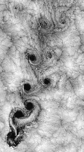
| 06h42min de 25 de março de 2005 |  | 1 393 × 2 500 (1,84 MB) | MatthiasKabel | {{FPC}} ''This Landsat 7 image of clouds off the Chilean coast near the Juan Fernandez Islands (also known as the Robinson Crusoe Islands) on September 15, 1999, shows a unique pattern called a "von Kármán vortex street." This pattern has long been |
Utilização local do ficheiro
As seguintes 5 páginas usam este ficheiro:
Utilização global do ficheiro
As seguintes wikis usam este ficheiro:
- ar.wiki.x.io
- bn.wiki.x.io
- bn.wikibooks.org
- ca.wiki.x.io
- da.wiki.x.io
- de.wiki.x.io
- en.wiki.x.io
- Juan Fernández Islands
- Pattern
- Talk:Turbulence
- Kármán vortex street
- Wikipedia:Featured picture candidates/Von Kármán vortex street
- Wikipedia:Featured picture candidates/April-2005
- User talk:Brian0918/Free images
- Wikipedia:WikiProject Physics
- Portal:Weather/Selected picture archive
- Wikipedia:WikiProject Chile
- Portal:Chile
- Portal:Weather/Selected picture/6
- Wikipedia:Featured pictures/Natural phenomena/Others
- Gas
- User:Daniel Mietchen/Science communication gallery
- Wikipedia:WikiProject Physics/Recognized content
- User:AndyTheGrump/Sandbox
- Wikipedia:WikiProject Chile/Quality content
- Patterns in nature
- Portal:Weather/Selected picture
- Portal:Chile/Recognized content
- Wikipedia:Picture of the day/August 2023
- Wikipedia:Featured picture candidates/July-2023
- Wikipedia:Featured picture candidates/Kármán vortex street
- Wikipedia:Featured pictures thumbs/77
- Template:POTD/2023-08-11
- Wikipedia:Wikipedia Signpost/2023-08-15/Featured content
- Wikipedia:Main Page history/2023 August 11
- Wikipedia:Main Page history/2023 August 11b
- Wikipedia:Wikipedia Signpost/Single/2023-08-15
- User talk:Bammesk/Archive 03
- en.wikiquote.org
- es.wiki.x.io
- eu.wiki.x.io
- fa.wiki.x.io
- fa.wikibooks.org
- fi.wiki.x.io
- fr.wiki.x.io
Ver mais utilizações globais deste ficheiro.


