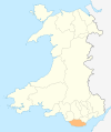
Ficheiro:Wales Vale of Glamorgan locator map.svg

Dimensões desta antevisão em PNG do ficheiro SVG: 502 × 600 píxeis Outras resoluções: 201 × 240 píxeis | 402 × 480 píxeis | 643 × 768 píxeis | 857 × 1 024 píxeis | 1 714 × 2 048 píxeis | 1 047 × 1 251 píxeis.
Imagem numa resolução maior (ficheiro SVG, de 1 047 × 1 251 píxeis, tamanho: 146 kB)
Histórico do ficheiro
Clique uma data e hora para ver o ficheiro tal como ele se encontrava nessa altura.
| Data e hora | Miniatura | Dimensões | Utilizador | Comentário | |
|---|---|---|---|---|---|
| atual | 19h00min de 4 de maio de 2010 |  | 1 047 × 1 251 (146 kB) | NordNordWest | {{int:filedesc}} {{Information |Description= {{de|Lagekarte von Vale of Glamorgan in Wales}} {{en|Locator map of Vale of Glamorgan in Wales}} |Source={{Own}} |Date=2010-05-04 |Author={{U|NordNordWest}} |Permission={{self|cc-by-sa-3.0}} |other_versions= } |
Utilização local do ficheiro
A seguinte página usa este ficheiro:
Utilização global do ficheiro
As seguintes wikis usam este ficheiro:
- en.wiki.x.io
- Vale of Glamorgan
- Cowbridge
- Wick, Vale of Glamorgan
- Penarth
- Llantwit Major
- Ewenny
- Ogmore, Vale of Glamorgan
- Breaksea Point
- Category:Vale of Glamorgan
- MOD St Athan
- Cosmeston Medieval Village
- Colwinston
- Sully, Vale of Glamorgan
- Ogmore Castle
- Lavernock
- Rhoose
- Barry, Vale of Glamorgan
- Cardiff Airport
- Aberthin
- Ogmore-by-Sea
- Peterston-super-Ely
- Rhoose Point
- St Athan
- Wenvoe transmitting station
- Dinas Powys
- Culverhouse Cross
- Corntown
- St Brides Major
- Bonvilston
- Southerndown
- Boverton
- Llandough, Penarth
- Porthkerry
- Gileston
- Wenvoe
- Schwyll Aquifer
- Romilly, Vale of Glamorgan
- Gladstone, Vale of Glamorgan
- Aberthaw
- Aberthaw power stations
- Holton, Vale of Glamorgan
- Cogan, Vale of Glamorgan
- Penarth Head
- Cold Knap
- Cosmeston Lakes Country Park
- Llansannor
- Cadoxton, Vale of Glamorgan
- St Andrews Major
- Wenvoe Castle Golf Club
- Penmark
Ver mais utilizações globais deste ficheiro.
