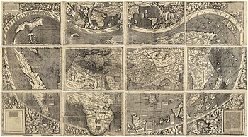
Mapa de Waldseemüller
O Mapa de Waldseemüller, ou Universalis Cosmographia, é um mapa do mundo impresso pelo cartografo alemão Martin Waldseemüller, originalmente publicado em abril de 1507.[1][2]


É o primeiro mapa do mundo a utilizar o termo "América".[3] Foi desenhada baseando-se no mapa de Ptolomeu, expandido para acomodar as Americas e as altas latitudes.[4]
Uma cópia do mapa ainda existe na Biblioteca do Congresso em Washington, D.C..[5][6][7]
Ver também
editarReferências
editar- ↑ Waldseemüller, Martin (1507), Globensegmente, consultado em 3 de julho de 2012
- ↑ E.G. Ravenstein, Martin Behaim: His Life and His Globe, London, George Philip, 1908, p.36.
- ↑ Alexander, David (5 de dezembro de 2007). «Map that named America is a puzzle for researchers». Reuters. Consultado em 5 de dezembro de 2007
- ↑ Snyder, John P. (1993). Flattening the Earth: 2000 Years of Map Projections, p. 33. Chicago: The University of Chicago Press.
- ↑ Hébert, John (setembro de 2003). «The Map That Named America». Library of Congress. Library of Congress Information Bulletin. Consultado em 16 de abril de 2012
- ↑ Hunc in modum terra iam quadripartita cognoscitur: & sunt tres primae partes continentes: quarta est insula: cum omni quamque mari circumdata conspiciatur...Nunc vero & haec partes sunt latius lustratae & alia quarta pars per Americum Vesputium (ut in sequentibus audietur) inuenta est.
- ↑ «Unexpected find in LMU Library: Rare map related to America's "birth certificate"» (Nota de imprensa). Ludwig-Maximilians-Universität München. 3 de julho de 2012. Consultado em 3 de julho de 2012
Fontes
editar- Lester, Toby: A world redrawn
- Toby Lester, "Putting America on the Map", Smithsonian, Volume 40, Number 9, p. 78, December 2009
Literatura
editar- Lester, Toby: The Fourth Part of the World: An Astonishing Epic of Global Discovery, Imperial Ambition, and the Birth of America, Free Press, 2010, 496 p. ISBN 1-4165-3534-9.
Ligações externas
editar- 1507 Waldseemüller Map from the US Library of Congress
- H.Res. 287 "America" (AHasting D-FL23) in Congress on July 11, 2007
- TOPS Lecture at Library of Congress, Drs. France and Easton
- Pope Valley School Cuts 1507 Globe Map for World Geography Month, Riccardo Gaudino, America500tv April 20, 2007.
- National Geographic News: US Buys Oldest Map Marked "America"
- Martin Waldseemüller - Bell Library: Maps and Mapmakers
- World Digital Library presentation of Universalis cosmographia secundum Ptholomaei traditionem et Americi Vespucii aliorum que lustrationes or A Map of the Entire World According to the Traditional Method of Ptolemy and Corrected with Other Lands of Amerigo Vespucci. Library of Congress.